![]()
Appendix C
Finding Underground Water- C-1: Hydrological cycle
- C-2: Groundwater
- C-3: Groundwater movement
- C-4: Tropical hydrogeology
- C-5: References
People can not exist without good water. Drinking water is obtained from two main sources: surface water and groundwater. These sources are connected by the hydrological cycle.
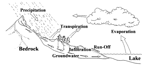
The water (hydrological) cycle is the continuous circulation of water between land, air and ocean (see Figure 18). The cycle has no beginning or end. Radiation from the sun evaporates water from rivers, lakes and oceans. The water vapour rises, collects to form clouds and then falls back to earth as precipitation (rain, hail, sleet or snow).
When precipitation falls on land, some of the water runs off into the lakes and rivers, some is evaporated back into the atmosphere, some is adsorbed by plant roots and re-enters the atmosphere by a process known as transpiration (evapotranspiration), and some of the water infiltrates into the soil. This recharge water is known as groundwater. Groundwater moves slowly through the subsurface into rivers and oceans where it is evaporated to complete the hydrological cycle. Groundwater makes up 97% of the world's freshwater available for human use, is found almost everywhere and it is of relatively good quality in most areas (see Table 12).
Water infiltrates downward until it reaches a depth where water fills all of the openings in soil and cracks in rock. This is called the saturated zone. The top of the saturated zone is called the water table (see Figure 18). The depth to the water table depends on the nature of the geological materials and the slope of the land surface. During rainy seasons the water table rises; during the dry season it falls.
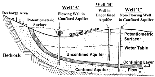
Water occurs in all geologic materials; if enough openings are interconnected, water can move in appreciable quantities and the deposit is called an aquifer. Aquifers may be found in the bedrock and in the overburden overlying the bedrock.
Bedrock aquifers derive their permeability from joints, bedding planes, fractures and solution channels. The yield of bedrock aquifers is highly variable, depending on the width and interconnectedness of fractures. While water can usually be found within rocks, it is hard to predict the depth of yield of this water. Many Lifewater wells have been sucessfully drilled in limestone or andstone.
Overburden aquifers are deposits of sand or gravel which are of sufficient extent and permeability to store and transmit water and are readily recharged by percolating water from the surface (see Figure 19). Saturated sand and gravel yields lots of water; fine sand or silt formations yield water more slowly. When the upper limit of an aquifer is the top of the saturated zone (water table), the aquifer is called a water-table or unconfined aquifer (see Figure 19). Even where surficial soils are low yielding clays (aquitards), good water bearing aquifers are often found at the overburden/ bedrock interface.
Figure 18: The Hydrologic Cycle
An aquifer that is overlain by material through which water cannot easily pass (aquiclude) is called an unconfined aquifer (see Figure 19). Water in confined aquifers is under pressure caused by the weight of the confining materials, the elevation differences in the aquifer, and the restriction in movement of water in the aquifer. When a well is drilled into a confined aquifer, water rises in the well to a point somewhere above the top of the aquifer (piezometric surface). Sometimes the pressure is so high that water rises to ground surface and wells overflow.
When a well is pumped, the water table is lowered forming a cone of depression (see Figure 20). The shape of the cone is determined by the pumping rate of the well and the permeability of the rocks surrounding the well.
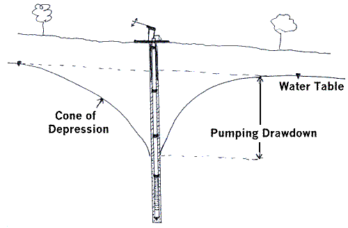
As water is withdrawn, the aquifer must eventually be replenished to keep producing. Water table aquifers are usually recharged from local sources of precipitation. Confined aquifers, however, frequently receive recharge many miles from the well.
The residence time of groundwater (the amount of time water spends underground), varies from a few days to thousands of years. Groundwater moves at a very slow rate, usually much less than 1 metre per day (see Table 12).
| Surface Water | Groundwater | |
| Understanding | Easily seen & observed | Invisible, mysterious, complex. |
| Where Found | Streams, rivers, lakes etc. | Everywhere beneath the surface in layers of sand, gravel, clay or cracked rock. Rarely forms underground "streams" or "lakes" |
| Availability | Active groundwater systems account for 95% of the world's available freshwater! (Freeze & Cherry, 1985) | |
| Uses | Drinking water, food (fish, trapping, rice etc), transportation, bird/animal habitat, power, aesthetics and spiritual health. | Drinking water, energy, maintaining flow in surface water courses. |
| Flow Direction | Downhill | Usually from high to low elevations. |
| Flow Rate | Fast (metres/second) | Slow (metres per year) |
| Quantity (yield) | Easy to assess. Supply problems rare. | Drilling and pumping. Lots of water in sand and gravel or heavily fractured rock. Low yields in silt and clay or unfractured rock. |
| Quality | Low dissolved (soft, low iron) High organics Temperature changes Mud, clay, algae | High dissolved (hard, high iron) Low organics Constant, cool temp No suspended solids |
| Consistency | Changes with seasons | Constant over time |
| Safety | Variable bacteria/virus counts | Safe because of filtration and natural purification processes |
| Treatment | Continuous chlorination | Initial chlorination |
| Cost | High | Low |
| Contamination Risk | Easily contaminated | Not easily contaminated. |
| Contamination Remediation | Natural breakdown by sun, air, mixing etc. | Clean-up difficult or impossible; May take many decades. |
The earth filters and purifies water moving through it. Since groundwater is protected by earth, it is far less vulnerable to contamination than the water in rivers and lakes (see Table 12).
As water moves through the ground, it dissolves minerals from soil and rock. In general, groundwater from deep sand or rock layers contains more minerals than water from shallow deposits. Because the water has travelled a greater distance underground, it has had more time to slowly dissolve minerals. Sometimes leached iron gives groundwater a strong red colour and bitter "mineral" taste (see Table 12). Although this may be unpleasant, the water is potable (safe to drink). Sometimes, however, safe water supplies are not used because the water is "cold" or has "no taste" or a "bad taste" (UN, 1981).
C-3: Groundwater Movement
There are two fundamental components to groundwater movement:
- water flows downhill (hydraulic gradient): Water always moves downward due to the potential energy from gravity. Just like a stream can not flow up a hill, groundwater only flows from areas of high groundwater levels to areas of low groundwater levels.
- Water flows through open spaces (hydraulic conductivity): groundwater can only move through interconnected spaces. Water has the potential to move rapidly through subsurface materials which has many open, interconnected spaces (ie., coarse sand, fissured sandstone). Conversely, clay and bedrock generally have poor water transmitting characteristics.
As shown on Figure 21, the bedrock over much of Africa are Precambrian formations which are dominated by relatively impermeable crystalline rocks such as granites, schists, quartzites, and gneisses (Houston, 1995). In these rocks, it is often necessary to drill 60-80 metres deep, wells often yield less than 2 m3/day and it is often necessary to pump from considerable depths (Dijon, 1981). Groundwater which does move through these rocks is concentrated in geological structures such as faults, shear zones and joint systems.
Figure 21: Generalized distribution of Rocks in Africa
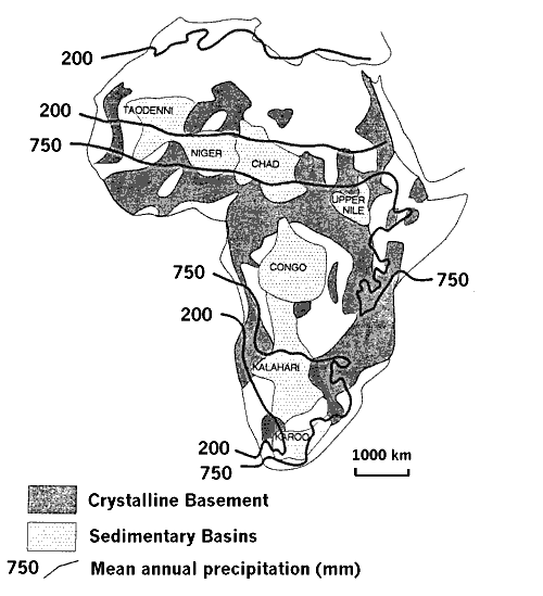
Sedimentary rocks (sandstone) are usually more permeable than crystalline (igneous or metamorphic) rocks. As shown on Figure 21, there are large sedimentary basins in central Africa. Local sedimentary deposits may exist along major rivers, lakes and ocean coasts.
In tropical environments, rock breaks down quickly, producing a zone of weathered material called saprolite or laterite. Surface soils are often underlain by a red-brown silty clay which does not function as a good aquifer (Selby, 1985). This material often grades into a silty sand containing some rounded fragments of unweathered rock (corestones). These deposits can yield significant quantities of water if coarser-grained materials are present. Corestones become larger and less rounded with depth until unweathered bedrock is encountered.
In humid tropical regions, complex saprolite profiles develop (Selby, 1985):
- a 0 to 2 m thick SOIL ZONE containing hard, dark red nodules in a sandy soil;
- a 1 to 10 m thick CRUST of reddish or brown blocks formed of cemented, hardened iron-rich nodules with tube-like cavities filled with red or ochre clay. Most minerals, except iron and aluminum oxides, have been leached from the crust;
- a 1 to 10 m thick MOTTLED ZONE of white kaolinitic clay with patches (mottles) of yellowish oxides. This zone is strongly leached and weathered;
- a 5 to 30 m thick PALLID ZONE of bleached kaolinitic clay;
- a WEATHERED ZONE up to 60 m thick which consists of deeply weathered rock still containing original rock structures;
- UNWEATHERED BEDROCK. Since the bedrock surface is generally far beneath the surface, few wells in tropical regions are drilled into pristine, unweathered bedrock.
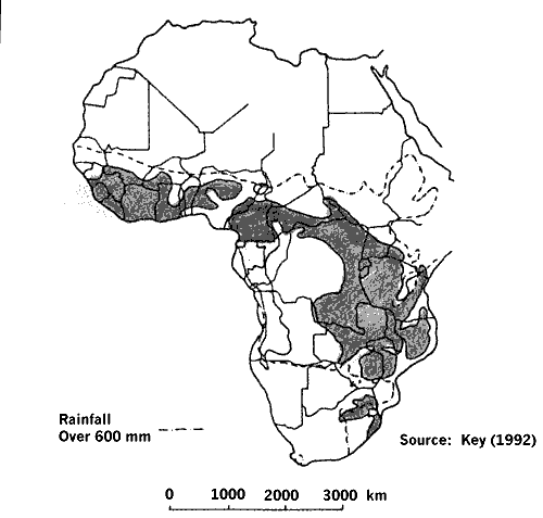
| As shown in Figure 22, groundwater is often found near the active weathering front, where permeabilities are higher than in the overlying, clay-rich soils and underlying unweathered bedrock. The underlying rock acts as an aquiclude, trapping groundwater in the immediately overlying weathering front (Key, 1992). As a result, the goal of many well drilling programs in humid tropical regions is to drill wells into the upper 1 - 3 m (5 - 10 ft) of weathered rock. Figure 23 shows areas in Africa where these weathered zone aquifers can be found. |
Typically, yields are highest where the weathering front is located over highly fractured bedrock in fault zones or adjacent to dikes which intrude along fracture zones; these are also the areas of deepest weathering. Astier and Paterson (1987) found that well yields were inversely related to distance from interpreted faults or dikes for a distance of 3 km (1.86 mi); i.e., closer to structure = higher yield).
Weathering process result in the development of permeable sandy soils between valleys, fine sands with clay on valley sides and poorly drained clay soils in the valley bottoms (Farquharson and Bullock, 1992). Rainfall tends to pass quickly into the upper sandy soils but reaches layers of reduced permeability at relatively shallow depths (often at the top of the weathered saprolite layer). Thus, while runoff is initially down into the soil, lower permeability at shallow depths produces lateral throughflow downslope towards the valley bottom (Farquharson and Bullock, 1992).
Figure 22: Weathered Zone Well Yield with Depth
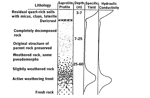
Figure 23: Location of Weathered Zone Aquifers in Africa
Astier, J. and N. Patterson (1987). Hydrogeological Interest of Aeromagnetic Maps in Crystalline and Metamorphic Areas. In: Exploration '87 Proceedings, Applications of Geophysics and Geochemistry, pp. 732-745.
Dijon, R. (1981) "Groundwater Exploration in Crystalline Rocks in Africa", Proceedings of the American Society of Civil Engineers, May 11-15, 1981.
Farquharson, F. and A. Bullock (1992) "The Hydrology of Basement Complex Regions of Africa with Particular Reference to Southern Africa", pp. 59-76 in Wright, E. and Burgess, W. (eds) Hydrogeology of Crystalline Basement Aquifers in Africa, Geological Society Special Publication No. 66, London.
Freeze, A. and J. Cherry (1985) Groundwater, Prentice-Hall, Englewood Cliffs, N.J.
Houston, J. (1995). Exploring Africa's groundwater Resources. International groundwater Technology, Vol. 1, No. 1, pp. 29-32.
Key, R. (1992) "An Introduction to the Crystalline Basement of Africa", pp. 29-57 in Wright, E. and Burgess, W. (eds) Hydrogeology of Crystalline Basement Aquifers in Africa, Geological Society Special Publication No. 66, London.
Selby, M.J. (1985). Earth's Changing Surface. Clarendon Press, Oxford, 607pp.
United Nations (1981) "Rural Water Supply", UN Dept. of Technical Cooperation for Development, Report of a United Nations Interregional Seminar, Uppsala, Swede, 6-17 October, 1980.